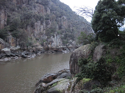
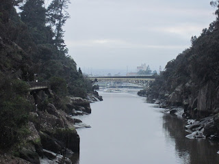
 We spent the night in Launceston, the second largest city in Tasmania, at the backpackers hostel. It was the first time we had seen a traffic light since leaving Hobart 3 days ago. Welcome back to "civilization". Tina and I opted to do the morning hike to the gorge since it would be the only serious walking we would do that day. The others chose to stay in to get their beauty sleep and meet us at the suspension bridge over the gorge about 90 minutes later. This suspension bridge was built around the turn of the century and could hold more than 2 people, although it did bounce as you walked on it. It was pretty amazing, within 20 minutes we were out of the city and walking the path along a beautiful, narrow, rock-faced gorge. I would have never guessed this rugged of an area was so nearby. Despite the rains in the west, the river was low; I would have liked to have had more water rushing through the gorge, but not as much as happened in 1929 when so much water came down the gorge it reached as high as the bottom of the bridge. I'm not sure exactly how high the bridge is, but it has to be at least 30-40 feet. That must have been an awesome, terrifying sight.
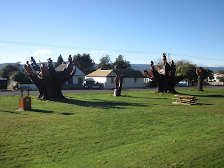
 The rest of the group arrived and off we went to Legerwood to view the WWI memorial carvings. After WWI, as was the fashion, the people of Legerwood planted trees in memory of the men and boys, the soldiers, who gave their lives in service to their country in the war to end all wars (if only it was). Legerwood is not a big town, maybe 200 currently, but even back then it would have only been slightly larger; a town the size where everyone pretty much knew everyone else, so when someone died in the war the whole town knew it and grieved as one. The trees grew large over the years and became too dangerous according to the town council, so the decision was made to cut them down. A piner from the local sawmill thought there was something wrong, something disrespectful, about removing memorial trees. Since the trees were going to come down, he offered to “carve” with a chainsaw the remaining “stumps” into various images in order to continue honoring those who had fallen far from home. His proposal was accepted and resulted in the memorial carvings of Legerwood; a modest tribute to those who gave the ultimate sacrifice.
 We stopped to taste some local hand-made cheddar cheese. You could really taste the difference aging has on the cheese. The cheese was good, but their ice cream was better. I can never pass on the opportunity to taste ice cream, so I tried the wattle seed. It was scrumptious. Can any ice cream taste bad? ........Yes it can, but not this time.

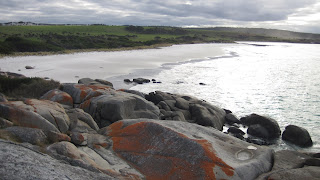
 After lunch we headed for our last stop of the day (except for the penguins) at the Bay of Fires (BoF). Now because of the magnificent scenery we had seen over the last few days, and the incorrect story I heard that the BoF is so named because of the red lichen that colors the rock, I was expecting fiery reds, scarlets, crimsons .....something like a scene from Dante’s Inferno. Alas, it was not to be. There were some rusty colored rocks and the BoF was named by the French explorers who saw a multitude of aboriginal campfires burning on the shore when they sailed into the bay. Don’t get me wrong it is a beautiful coastline, but I prefer the rugged vistas of the interior to those of the Eastern seaboard. However, what is cool about the Bay of Fires is that it is 35 kilometers long, has the longest stretch of uninterrupted beach in Tasmania, and the only access roads are at the two ends. So if you want to see the middle, you have to walk to get there; and I’m pretty sure you would have the beach all to yourself. Unfortunately we did not have enough time for that hike.
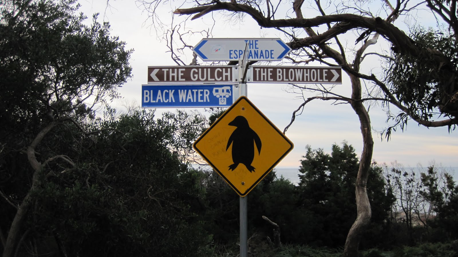
 Our home for the night was in Bicheno, a small coastal fishing town. After dropping off our stuff we headed out to see the penguins. Just after sunset a group of little penguins (they used to be called fairy penguins) who nest in the area will come home from their day at sea. You can almost set your watch by them. It was a short walk down to the rocks on the shore where we sat to wait. Andrew said they would come out of the water, walk on the path in front of us and then head into the surrounding scrub where they nest. Since they would be scared away by bright lights or our towering bodies, we had to sit in the dark and cover our torches (flashlights) with red cellophane; and definitely no flash photography. So unfortunately I have no photos. We sat there in the darkness looking into the night sky and listening to the sound of the “blowhole” (more on that later) roaring behind us. The sky was full of stars and you could easily locate the “Southern Cross”; a group of stars in the southern hemisphere equivalent to our “Big Dipper”. Sure enough, about 20 minutes after sitting down we heard some splashing and penguin noises. Then out of the darkness to our left a group of about 6 little penguins, maybe ten inches tall, waddled past directly in front of us, no more than three feet away. There was a place in the path where it was like a small step and one penguin had some trouble getting over it. It was pretty cute and funny watching him trying to hop up onto the rock. You had to laugh. In a few moments they disappeared into the darkness and we were done for the day.
 This was our last day and we awoke early to catch the sunrise from the Bicheno lookout high above “the Gultch”, a sliver of water sheltered by a small rocky island just off shore. The colors as the sun was coming up were fabulous; reds, oranges purples. The sky was on fire (this is how BoF should look). There was a bank of clouds on the horizon so we did not get a chance to see the sun slowly rise until it became a fully round golden orb, but it was still worth getting up early. On top of the hill is the “whalers tree”. In the old days when Bicheno was a whaling port, a young lad would sit up in the tree to look for whales. When one was spotted he would hang a flag on the appropriate branch pointing in the direction of the whale like a primitive GPS. The boat captains would see the flags and head in that direction to slaughter the defenseless blobs of blubber.
  Since we had a little time before leaving, Tina, Claudia and I went to see the blowhole. The blow hole is a narrowing crevasse between the rocks where waves come and then because of the increased pressure water shoots high into the air. The previous night while we were waiting for the penguins, the waves were strong and the blowhole was spouting like Menthos placed in a Coke bottle, this morning not so much. We watched it blow for a while and I kept getting nearer for a closer look at the mechanic. Tina warned me not to get too close or I would get wet. Not a minute later I’m standing in front of it saying aloud “Wow this wave is going to be a good one” (which it was), knowing that I was going to get soaked, but mesmerized and unable to move. It was like watching in slow motion as the wave came through the crack and erupted like “old Faithful” sending water a dozen feet high. I had just enough time to turn and take a step, so only half of me was drenched. We all had a good laugh.
 |
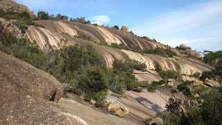
| The rocky trail |
No one wanted to go to the animal park so we headed directly to Wineglass Bay further down the eastern shore. Wineglass Bay Beach (WBB) perennially makes the list of one of the top ten beaches in the world. Like many of the beaches in Tasmania you can’t just drive up to them. If you want to get to WBB it’s a, 75 min walk up and over the mountain down to the beach. Of course it‘s a 75 minute walk back up over the mountain and this may contribute to its ranking. I have no idea what the actual beach is like because we never got there. Why you may ask would you go to one, if not the number one, top ten beaches in the world and not actually visit the beach, because the view of the beach from atop Mt. Amos (454 meters) is absolutely spectacular; plus it is the dead of winter and the water is still too cold to swim; and our time was limited so we had to make a choice. We could take the 2.5 hour hike to the beach, do the 2.5 hour climb, or do neither and hang out at another nearby beach with no hiking just an easy stroll. I knew Tina was in for the climb because we had
agreed on it the night before; Claudia was on the fence but decided to join us and did not regret her decision; Doris and her family opted for option three. Andrew wanted to join us, but he had smashed two fingers hooking up a trailer on the last tour and had them bandaged; on this climb you needed your hands as well as your feet. In the past I’ve said “climbed” a mountain, but that usually means just hiking up the mountain; this one was different. Andrew told us we would need our hands as well as our feet, and the sign at the park posted warnings that the climb is difficult, should only be undertaking by the fittest, and that it could be dangerous...... so of course we had to go. Tina does a lot of hiking with her father in the hills and mountains of Germany, so she led our way up and down the mountain. The trail started
out like any other; a fairly easy, well marked path where you walked upright on two legs. That soon gave way to clambering around boulders, grabbing onto rocks to pull your self up, and scrambling on all fours over huge slabs of slick, weather smooth, granite poised at precarious angles just to make it more interesting. All the time you had to be looking for markers (little white painted triangles or small pieces of ribbon tied to the brush) every 20-30 meters to guide the way. Sometimes what looked like the correct or easiest path was not the right way to go. They weren’t always easy to spot, especially coming down. Thankfully it was dry. When wet the rock gets very slippery and if it were raining even a little we wouldn’t have attempted the climb. There was moisture in some spots and on the descent I took a wrong step, fell in the brush, and scratched my arm; it looked a lot worse because the blood. As we climbed higher the view got and we stopped for many pictures along the way. One nice thing about the climb is that
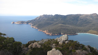
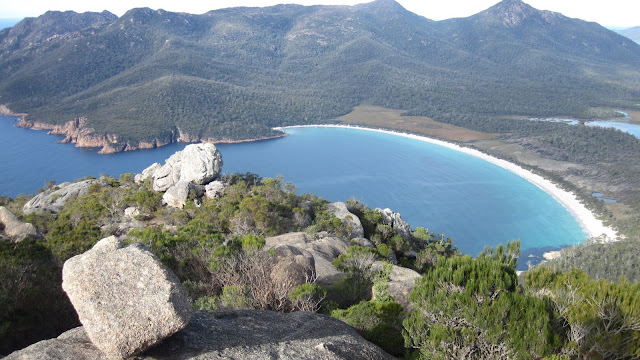
we couldn’t see WBB because it was still on the other side of the mountain. The only way to see it was to reach the top, so we climbed on. Even when we reached the top we still couldn’t immediately see the beach because mountaintop was so wide. We made our way to the other side and BAM! there it was Wineglass Bay Beach; a perfect, symmetrical, crescent shaped beach of ashen sand, turquoise water, small white tipped waves rolling in through a narrow inlet, under a clear, cloudless blue sky, illuminated by the blazing yellow sun; another picture post card moment. If that wasn’t enough, as your eye follows the far end of the beach around the inlet, the coastline continues with rocky cliffs that trail around the end of the peninsula. We stayed on the mountain at least 20 minutes drinking in the beauty of Wineglass Bay, savoring the view, taking numerous photos, and enjoying some chocolate and cookies we had carried with us to the top. From our vantage point we could see that there were only four hardy folks who made the climb to the beach and as was no surprise we were the only ones at the top of Mt. Amos. Unfortunately we had to go back down. I found that a little more difficult because the signs were harder to locate and when descending if you fall forward you go rolling down the mountain.
 |
| Wineglass Bay Beach |
About half way down we did meet three fellow adventurers making their way up; a Tassie and two tourists. You could tell the Tassie, he was the one wearing shorts. In the end, we all said we would do the climb again before going to the beach. When I come back J I would like to hike to the beach and continue on to climb Mt. Freycinet on the other side for a mirror image view of the beach. This time I only took a sip from the Wineglass and a taste was not enough.
The final stop on our whirlwind Lap of Tassie was the small historic town of Ross. When the highway was built it bypassed the village of Ross thus preserving many of its’ colonial buildings and the 3rd oldest convict built bridge in Van Diemens land, as Tasmania was once known. The intersection of the two main streets in Ross is known as the “4 corners of Ross”. You could go through an entire sequence of life in one day by making the rounds at this single intersection. You start off at the first corner where you have a few drinks at the Town Hall – “Recreation”; move across the street to the
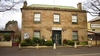 |
| Ross Bakery |
hotel where you might meet a fine lady of the evening – “Temptation”; after a night of carousing you wind up in the gaol on the next corner – “Damnation”; awakening in the morning, feeling bad for what you’ve done, you make your way to the final corner, the Church – “Salvation”, Ross has one other significant building, if you’re familiar with the Japanese animae “Kiki’s Delivery Service”, the Ross Bakery. The story is about a witch who makes deliveries on her broom and apparently Kiki lives on the second floor above the Ross Bakery. That concluded our official tour and we said our goodbyes, but the night had one more episode in store. Harry Potter had just come out that week but according to Tina would not be out in Germany for 3 months, so Tina, Doris and I went to see the movie. German, Chinese, American .............all watching a British film.......... in Tasmania. What a small wonderful world we live in.
Make friends wherever you roam!
norb


 About a 25 minute walk from Hahndorf is the home and studio of Hans Heysen; a renowned Australian landscape painter. I had seen several of his works in the museums I previously visited. The studio was cool, unfortunately they don’t let you take pictures inside. It’s a tall brick, barn-like structure, with a 20-25 foot high ceiling, fireplace, and huge frosted windows on the south wall. The glass had to be imported from Italy as they didn’t make it in Australia. It was a classic artist studio and you could see how valuable the light would be coming through the windows before the advent of electricity. With the windows closed the light filters through the frosted glass so subtly; you could see how it would be perfect for an artist. The house was cool too and you could see how it expanded from a one story cottage to accommodate their growing family of eight children. One other nice thing about the property is that they have information signs in spots where Hans may have painted some of his pictures along with a copy of the painting, so you can see his interpretation and the actual site. One of his favorite spots was the “Shady Pool”. I found a sunny spot by the “Shady Pool” to sit and have lunch; alone amongst the gum trees, with the warm sun shining down, it was sweet.